Gallery 0
Maps
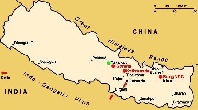
436 Nepal as a whole

Nepal is sandwiched between India and China. There are no trains in Nepal. You can fly to Kathmandu or take a bus from Delhi to Kathmandu, which takes about 36 hours, passes through Uttar Pradesh and Bihar in India, before crossing into Nepal at Birganj (Nepali side).
It takes about 8 hours from Birganj to reach Kathmandu, passing first through the Nepali lowlands, and then slowly ascending and descending and passing through Hetauda, Bharatpur, Mugling. This is a detour of several hours which will become unnecessary once a straighter route from Hetauda to Kathmandu through the mountains has been completed.
428 Kathmandu-Gorkha-Takukot-Pokhara

We have divided the route from Kathmandu to Takukot into three stages:
- Kathmandu to Abu Khaireni
- Abu Khaireni to Balu Suara
- Then walk from Balu Suara to Takukot
You can trace the bus route from Kathmandu on the above map. It passes through the following towns:
Kathmandu - Naubise - Baireni - Gajuri - Belkhu Bazar - Malekhu - Benighat - Kurinitar (Manakamana Cable Car Station) - Mugling - Abu Khaireni

435 - The map above shows Abu Khaireni, Gorkha, and the approximate location of Balu Suara and Takukot Ward 1.
The bus travels from Abu Khaireni to a spot near Imakahrka. Here it drives in or along the wide dry pebble-covered river bed of the Daraundi Khola (River Daraundi), sometimes fording the river. At the confluence of Bhusundi Khola and Daraundi Khola, it bears right following the bed of the latter until, south of the village of Maitar, it joins the road from Gorkha near a bridge and turns left (north). Just past Maitar it comes to a hamlet (called Balu Suara? Or is it part of Maitar), where the bus used to terminate (because the road beyond was blocked). There are a street restaurant, an inn (with dormitory accommodation) and a few shops. There is a ford which can be used by people and animals. By using this ford one can directly ascend to Takukot.
Nowadays the bus from Kathmandu is able to continue further north. People travelling from Kathmandu or from Gorkha can alight at a footbridge and walk from there to Maikot (Takukot Ward 1): taking about 150 minutes for non-natives.
505-b Takukot and the location of its 9 wards
The wards have traditional village names:

1 Maikot
2 Bhaledhunga
3 Dadathok (= Takukot ? )
4 Palkhu
5 Banjang
6 Bhahakot (Bahakot ?)
7 Mohoriya
8 Dandagaon
9 Bhaluswara
Note: The map shows two Dandagaon, one left and one right of the valley. Are both of them part of Takukot Ward 8?
To reach Maikot (1), one takes a bus from Kathmandu which by-passes Gorkha and used to end in Bhaluswara but now goes one stop further to Chanaute. One walks uphill from there.???
To reach Palkhu (4), one takes a bus from Kathmandu to Gorkha, then change for a bus in the direction of Deurali ???. From bus stop x, they walk, passing the following villages: Pandrung (see Map), Bhahakot (6), Bhanjang (5), Palkhu (= Ward 4)
Light cars and motor bikes can reach Takukot (a point 1 minute from Maikot School) from Gorkha by the following route: Haramtari, Ghyampesal, Panchkhuwa Deurali, Bhahakot, Palkhu, Ward No 1 Takukot.
There is a daily bus service from Panchkhuwa Deurali to Gorkha Bazar and continuing to Kathmandu.
Walking distances
The walking distances between the wards are as follows. When in doubt I have taken the longer rather than the shorter times. Uphill vs downhill (in the opposite direction) has not been taken into consideration. Website visitors please email the webmaster to clarify this (e.g. give different times for opposite direction).
1 > 2 : 15 minutes
2 > 3 : 15 minutes
3 > 4 : 15 minutes
4 > 5 : 5 minutes
5 > 6 : 10 minutes
6 > 7 : 45 minutes (passing through 5 and 4)
4 > 7 : 30 minutes
3 > 7 : 45 minutes (passing through 4)
7 > 8 : 20 minutes
8 > 9 : 30 minutes